
Parcourir par Mots clés libres
Nombre de documents : 7.
Guide technique pour la construction d'une base de données de vérité-terrain pour l'apprentissage et la validation des algorithmes de classification d'images satellites : Principes de base et manuel pratique mobilisant le logiciel QGIS et l'application QField.
Dupuy Stéphane, Jolivot Audrey, Lebourgeois Valentine, Lelong Camille.
2022.
Montpellier : CIRAD, 45 p.
![[img]](/style/images/fileicons/text.png)
Prévisualisation |
Prévisualisation |
Guide technique. Constitution d'une base de données de référence dédiée à l'apprentissage et la validation des classifications d'images satellites : la vérité-terrain.
Lelong Camille, Dupuy Stéphane.
2021.
Montpellier : CIRAD-ES-UMR TETIS, 16 p.
Prévisualisation |
Rapport méthodologique : Cartographie de l'occupation du sol sur le site des NIPPES à Haïti.
Dupuy Stéphane, Lelong Camille, Gaetano Raffaele.
2021.
Montpellier : CIRAD-ES-UMR TETIS, 45 p.
Prévisualisation |
Land cover maps of Antananarivo (capital of Madagascar) produced by processing multisource satellite imagery and geospatial reference data.
Dupuy Stéphane, Defrise Laurence, Gaetano Raffaele, Andriamanga Valérie, Rasoamalala Eloise.
2020.
Data in Brief, 31:105952, 13 p.
Prévisualisation |
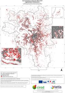
Carte d'évolution du bâti entre 2003 et 2017. Agglomération d'Antananarivo.
Dupuy Stéphane, Defrise Laurence, Burnod Perrine.
2019.
Montpellier : CIRAD-UMR TETIS, 1 carte , échelle : 1:50000
![[img]](http://agritrop.cirad.fr/style/images/fileicons/text.png)
Prévisualisation |
![[img]](http://agritrop.cirad.fr/594286/2/Carte_evolution_Tana_A0_v3.jpeg)
 Prévisualisation |
Mapping land cover on Reunion Island in 2017 using satellite imagery and geospatial ground data.
Dupuy Stéphane, Gaetano Raffaele, Le Mézo Lionel.
2019.
Data in Brief, 28:104934, 12 p.
Prévisualisation |
Production des cartes de l'occupation du sol agricole à la Réunion à partir d'images satellites 2016 – 2019 - Rapport méthodologique.
Dupuy Stéphane, Gaetano Raffaele.
2019.
Saint-Pierre : CIRAD-ES-UMR TETIS, 61 p.
Prévisualisation |


