
Parcourir par Mots clés libres
Nombre de documents : 46.
Article de revue
Quantifying the impact of Great Green Wall and Corporate plantations on tree density and biomass in Sahelian Senegal.
Cofélas Fassinou Fréjuste Joseph, Cesaro Jean-Daniel, Nungi-Pambu Maïalicah, Fensholt Rasmus, Brandt Martin, Akodewou Amah, Diouf Abdoul Aziz, Mbaye Tamsir, Taugourdeau Simon.
2024.
Trees, Forests and People, 16:100569, 13 p.
![[img]](/style/images/fileicons/text.png)
Prévisualisation |
Spatial distribution of degradation and deforestation of palm swamp peatlands and associated carbon emissions in the Peruvian Amazon.
Marcus Matthew S., Hergoualc'H Kristell Anaïk, Honorio Coronado Eurídice N., Gutiérrez-Vélez Víctor Hugo.
2024.
Journal of Environmental Management, 351:119665, 13 p.
![[img]](http://agritrop.cirad.fr/607690/1.hassmallThumbnailVersion/Marcus%20et%20al%2023%20Spatial%20distribution%20of%20degradation%20and%20deforestation%20of%20palm%20swamp%20peatlands%20and%20associated%20carbon%20emissions%20in%20the%20Peruvian%20Amazon.pdf)
 Prévisualisation |
Forest landscape restoration: Spectral behavior and diversity of tropical tree cover classes.
Eiti Haneda Leo, Brancalion Pedro H.S., Molin Paulo G., Pinheiro Ferreira Matheus, Silva Carlos Alberto, Torres de Almeida Catherine, De Resende Angélica Faria, Brossi Santoro Giulio, Rosa Marcos R., Guillemot Joannès, Le Maire Guerric, Feret Jean Baptiste, Alves de Almeida Danilo Roberti.
2023.
Remote Sensing Applications. Society and Environment, 29:100882, 15 p.
![[img]](http://agritrop.cirad.fr/style/images/fileicons/text.png)
Estimating crop parameters using Sentinel-1 and 2 datasets and geospatial field data.
Mercier Audrey, Betbeder Julie, Denize Julien, Roger Jean-Luc, Spicher Fabien, Lacoux Jérôme, Roger David, Baudry Jacques, Hubert-Moy Laurence.
2021.
Data in Brief, 38:107408, 5 p.
Prévisualisation |
Evaluation of sentinel-1 and 2 time series for land cover classification of forest–agriculture mosaics in temperate and tropical landscapes.
Mercier Audrey, Betbeder Julie, Rumiano Florent, Baudry Jacques, Gond Valéry, Blanc Lilian, Bourgoin Clément, Cornu Guillaume, Ciudad Carlos, Marchamalo Miguel, Poccard-Chapuis René, Hubert-Moy Laurence.
2019.
Remote Sensing, 11:979, 20 p.
Prévisualisation |
Mapping land cover on Reunion Island in 2017 using satellite imagery and geospatial ground data.
Dupuy Stéphane, Gaetano Raffaele, Le Mézo Lionel.
2019.
Data in Brief, 28:104934, 12 p.
Prévisualisation |
Near real-time agriculture monitoring at national scale at parcel resolution: Performance assessment of the Sen2-Agri automated system in various cropping systems around the world.
Defourny Pierre, Bontemps Sophie, Bellemans Nicolas, Cara Cosmin, Dedieu Gérard, Guzzonato Eric, Hagolle Olivier, Inglada Jordi, Nicola Laurentiu, Rabaute Thierry, Savinaud Mickael, Udroiu Cosmin, Valero Silvia, Bégué Agnès, Dejoux Jean-François, El Harti Abderrazak, Ezzahar Jamal, Kussul Nataliia, Labbassi Kamal, Lebourgeois Valentine, Miao Zhang, Newby Terrence, Nyamugama Adolph, Salh Norakhan, Shelestov Andrii, Simonneaux Vincent, Traoré Pierre Sibiry, Traore Souleymane Sidi, Koetz Benjamin.
2019.
Remote Sensing of Environment, 221 : 551-568.
Prévisualisation |
Spatial modeling of mosquito vectors for rift valley fever virus in northern Senegal: Integrating satellite-derived meteorological estimates in population dynamics models.
Tran Annelise, Fall Assane Gueye, Biteye Biram, Ciss Mamadou, Gimonneau Geoffrey, Castets Mathieu, Talla Seck Monar, Chevalier Véronique.
2019.
Remote Sensing, 11 (9):1024, 24 p.
Prévisualisation |
Understanding the drivers of deforestation and agricultural transformations in the Northwestern uplands of Cambodia.
Kong Rada, Diepart Jean-Christophe, Castella Jean-Christophe, Lestrelin Guillaume, Tivet Florent, Belmain Elisa, Bégué Agnès.
2019.
Applied Geography, 102 : 84-98.
Mapping ecosystem services at the regional scale: the validity of an upscaling approach.
Le Clec'h Solen, Sloan Sean, Gond Valéry, Cornu Guillaume, Decaëns Thibaud, Dufour Simon, Grimaldi Michel, Oszwald Johan.
2018.
International Journal of Geographical Information Science, 32 (8) : 1593-1610.
Monitoring mangrove forests after aquaculture abandonment using time series of very high spatial resolution satellite images: A case study from the Perancak estuary, Bali, Indonesia.
Proisy Christophe, Viennois Gaëlle, Sidik Frida, Andayani Ariani, Enright James Anthony, Guitet Stéphane, Gusmawati Niken Financia, Lemonnier Hugues, Muthusankar Gowrappan, Olagoke Adewole, Prospéri Maria-Juliana, Rahmania Rinny, Ricout Anaïs, Soulard Benoit, Suhardjono Suhardjono.
2018.
Marine Pollution Bulletin, 131 (Part B), n.spéc. Indonesia seas management : 61-71.
Potential of satellite imagery to study the effect of natural vegetation on the spatial distribution of greyback canegrub, Dermolepida albohirtum, in Australia.
Soti Valérie, Tran Annelise, Goebel François-Régis.
2018.
International Sugar Journal, 120 (1430) : 144-148. Congress of the International Society of Sugar CaneTechnologist. 29, Chiang Mai, Thaïlande, 5 Décembre 2016/8 Décembre 2016.
SMOS based high resolution soil moisture estimates for Desert locust preventive management.
Escorihuela Maria-José, Merlin Olivier, Stefan Vivien, Moyano Gorka, Eweys Omar Ali, Zribi Mehrez, Kamara Sidi, Benahi Ahmed Salem, Babah Ebbe Mohamed Abdallahi Ould, Chihrane Jamal, Ghaout Saïd, Cissé Sory, Diakite Fakaba, Lazar Mohamed, Pellarin Thierry, Grippa Manuela, Cressman Keith, Piou Cyril.
2018.
Remote Sensing Applications. Society and Environment, 11 : 140-150.
Prévisualisation |
Expansion of oil palm and other cash crops causes an increase of the land surface temperature in the Jambi province in Indonesia.
Sabajo Clifton R., Le Maire Guerric, June Tania, Meijide Ana, Roupsard Olivier, Knohl Alexander.
2017.
Biogeosciences, 14 (20) : 4619-4635.
Prévisualisation |
Gold-rush in a forested El Dorado: deforestation leakages and the need for regional cooperation.
Dezécache Camille, Faure Emmanuel, Gond Valéry, Salles Jean Michel, Vieilledent Ghislain, Hérault Bruno.
2017.
Environmental Research Letters, 12 (3):034013, 11 p.
Prévisualisation |
Remote sensing of industrial palm groves in Cameroon.
Komba Mayossa Prune Christobelle, Gadal Sébastien, Roda Jean-Marc.
2017.
ASM Science Journal (1), n.spéc. ICT-Bio : 16-45.
Prévisualisation |
Simulating the canopy reflectance of different eucalypt genotypes with the DART 3-D model.
De Castro Oliveira Julianne, Feret Jean Baptiste, Ponzoni Flávio Jorge, Nouvellon Yann, Gastellu Etchegorry Jean-Philippe, Camargo Campoe Otávio, Stape Jose Luiz, Estraviz Rodriguez Luiz Carlos, Le Maire Guerric.
2017.
IEEE Journal of Selected Topics in Applied Earth Observations and Remote Sensing, 10 (11) : 4844-4852.
Synthetic Aperture Radar (SAR) images improve habitat suitability models.
Betbeder Julie, Laslier Marianne, Hubert-Moy Laurence, Burel Françoise, Baudry Jacques.
2017.
Landscape Ecology, 32 : 1867-1879.
Texture-based classification for characterizing regions on remote sensing images.
Borne Frédéric, Viennois Gaëlle.
2017.
Journal of Applied Remote Sensing, 11 (3):e036028, 31 p.
A combined random forest and OBIA classification scheme for mapping smallholder agriculture at different nomenclature levels using multisource data (simulated sentinel-2 time series, VHRS and DEM).
Lebourgeois Valentine, Dupuy Stéphane, Vintrou Elodie, Ameline Maël, Butler Suzanne, Bégué Agnès.
2017.
Remote Sensing, 9 (3):259, 20 p.
Prévisualisation |
Climate change projections of West Nile virus infections in Europe: Implications for blood safety practices.
Semenza Jan C., Tran Annelise, Espinosa Laura, Sudre Bertrand, Domanovic Dragoslav, Paz Shlomit.
2016.
Environmental Health, 15 (28), suppl. 1. Healthy-Polis: Challenges and Opportunities for Urban Environmental Health and Sustainability, 12 p.
Prévisualisation |
Forest cover and carbon stock change dynamics in the Democratic Republic of Congo: Case of the wood-fuel supply basin of Kinshasa.
Gond Valéry, Dubiez Emilien, Boulogne Marine, Gigaud Morgan, Peroches Adrien, Pennec Alexandre, Fauvet Nicolas, Peltier Régis.
2016.
Bois et Forêts des Tropiques (327) : 19-28.
Prévisualisation |
Multiple patterns of forest disturbance and logging shape forest landscapes in Paragominas, Brazil.
Tritsch Isabelle, Sist Plinio, da Silva Narvaes Igor, Mazzei Lucas, Blanc Lilian, Bourgoin Clément, Cornu Guillaume, Gond Valéry.
2016.
Forests, 7 (315), 15 p.
Prévisualisation |
Rift Valley fever vector diversity and impact of meteorological and environmental factors on Culex pipiens dynamics in the Okavango Delta, Botswana.
Hammami Pachka, Tran Annelise, Kemp Alan, Tshikae Power, Kgori Patrick M., Chevalier Véronique, Paweska Janusz, Jori Ferran.
2016.
Parasites and Vectors, 9 (434), 17 p.
Prévisualisation |
Assessing ecological habitat structure from local to landscape scales using synthetic aperture radar.
Betbeder Julie, Hubert-Moy Laurence, Burel Françoise, Corgne Samuel, Baudry Jacques.
2015.
Ecological Indicators, 52 : 545-557.
Mapping landscape friction to locate isolated tsetse populations candidate for elimination.
Bouyer Jérémy, Dicko Ahmadou Hamady, Cecchi Giuliano, Ravel Sophie, Guerrini Laure, Solano Philippe, Vreysen Marc J.B., De Meeus Thierry, Lancelot Renaud.
2015.
Proceedings of the National Academy of Sciences of the United States of America, 112 (47) : 14575-14580.
Prévisualisation |
Prévisualisation |
Chapitre d'ouvrage
Availability and integration of agro-environmental data: The French case.
Debaeke Philippe, Aubertot Jean-Noël, Bardy Marion, Bertuzzi Patrick, Constantin Julie, Durand Patrick, Guichard Laurence, Mignolet Catherine, Munier-Jolain Nicolas, Thérond Olivier, Wigneron Jean-Pierre, Ballot Rémy, Cellier Pierre, Justes Eric, Huard Frédéric, Le Bas Christine, Richard Guy.
2022.
In : Landscape Agronomy: Advances and challenges of a territorial approach to agricultural issues. Rizzo Davide (ed.), Marraccini Elisa (ed.), Lardon Sylvie (ed.). Cham : Springer International Publishing , 38 p.
ISBN 978-3-031-05263-7
Characterizing tropical forests with multispectral imagery.
Helmer E.H., Goodwin Nicholas R., Gond Valéry, Souza Carlos M. Jr, Asner Gregory P..
2015.
In : Land Resources Monitoring, Modeling and Mapping with Remote Sensing. Thenkabail Prasad S. (ed.). Boca Raton : CRC Press , 363-391.
(Remote Sensing Handbook, 2)
ISBN 978-1-4822-1795-7
Communication avec actes
Coupling Sentinel-2 images and STICS crop model to map soil hydraulic properties.
Lammoglia Sabine Karen Djidemi, Chanzy André, Guérif Martine.
2020.
In : Crop modelling for agriculture and food security under global change: Book of abstracts. CIRAD, INRAE, INRIA. Montpellier : CIRAD , Résumé, 167-168.
International Crop Modelling Symposium (iCROPM 2020). 2, Montpellier, France, 3 Février 2020/5 Février 2020.
Prévisualisation |
Forecasts of desert locust presence in Morocco coupling remote sensing imagery and field surveys.
Smiej Mohammed F., Layelmam Mohammed, Atillah Abderrahman, Piou Cyril, Ghaout Saïd.
2019.
In : 13th International Congress of Orthopterology: Abstract book 2019. University Ibn Zohr, National Center for Control of Desert Locust, Orthopterists Society. Agadir : University Ibn Zohr , Résumé, p. 36.
(Metaleptea)
International Congress of Orthopterology. 13, Agadir, Maroc, 24 Mars 2019/28 Mars 2019.
Prévisualisation |
Impacts of FMNR on the agricultural performance of smallholder farming systems at landscape scale in Senegal.
Leroux Louise, Gbodjo Jean Eudes, Djiba S., Tounkara Adama, Ndao Babacar, Diouf Abdoul Aziz, Soti Valérie, Affholder François, Tall F., Clermont-Dauphin Cathy.
2019.
In : 4th World Congress on Agroforestry. Book of abstracts. Dupraz Christian (ed.), Gosme Marie (ed.), Lawson Gerry (ed.). CIRAD, INRA, World Agroforestry, Agropolis International, MUSE. Montpellier : CIRAD-INRA , Résumé, p. 367.
World Congress on Agroforestry. 4, Montpellier, France, 20 Mai 2019/22 Mai 2019.
Prévisualisation |
Prévisualisation |
A remote sensing based approach for optimizing sampling strategies in tree monitoring and agroforestry systems mapping.
Ndao Babacar, Leroux Louise, Diouf Abdoul Aziz, Soti Valérie, Sambou Bienvenu.
2019.
In : 4th World Congress on Agroforestry. Book of abstracts. Dupraz Christian (ed.), Gosme Marie (ed.), Lawson Gerry (ed.). CIRAD, INRA, World Agroforestry, Agropolis International, MUSE. Montpellier : CIRAD-INRA , Résumé, p. 563.
World Congress on Agroforestry. 4, Montpellier, France, 20 Mai 2019/22 Mai 2019.
Prévisualisation |
Extracting multi-layer networks from Sentinel-2 satellite image time series.
Interdonato Roberto, Gaetano Raffaele, Lo Seen Chong Danny, Roche Mathieu.
2018.
In : Complex networks 2018: The 7th International Conference on Complex Networks and their Applications. Book of abstracts. Cherifi Hocine (ed.), Aiello Luca Maria (ed.), Cherifi Chantal (ed.), Lio Pietro (ed), Lambiotte Renaud (ed.), Rocha Indiana Luis Mateus (ed.). Cambridge : International Conference on Complex Networks and their Applications , 240-242.
ISBN 978-2-9557050-2-5 International Conference on Complex Networks and their Applications. 7, Cambridge, Royaume-Uni, 11 Décembre 2018/13 Décembre 2018.
Prévisualisation |
SMOS based high resolution soil moisture estimates for Desert locust preventive management.
Escorihuela Maria-José, Merlin Olivier, Georgiana Stefan Vivien, Indrio Gianfranco, Piou Cyril.
2018.
. Valencia : IEEE , 8284-8287.
ISBN 978-1-5386-7150-4 International Geoscience and Remote Sensing Symposium (IGARSS 2018), Valencia, Espagne, 22 Juillet 2018/27 Juillet 2018.
Uso de Geotecnologias para a detecção de Sistemas Integrados de Produção Agropecuária: Uma contribuição para o Monitoramento da Agricultura de Baixa Emissão de Carbono.
Kuchler Calvano Patrick, Simoes Margareth, Ferraz Rodrigo P.D., Bégué Agnès.
2018.
In : Anais 7º Simpósio de Geotecnologias no Pantanal. EMBRAPA. Jardim : Embrapa Informática Agropecuária/INPE , 1068-1077.
Simpósio de Geotecnologias no Pantanal. 7, Jardim, Brésil, 20 Octobre 2018/24 Octobre 2018.
Prévisualisation |
Communication par affiche
Remote sensing techniques for calculating the above-ground biomass stored in agroforestry systems open the way for monitoring restoration policies.
Akodewou Amah, Oumarou Palou Madi, Peltier Régis.
2022.
In : En transition vers un monde viable. Québec : Université de Laval-IUAF-ICRAF , Résumé, 1 p.
Congrès mondial d'agroforesterie. 5, Québec, Canada, 17 Juillet 2022/20 Juillet 2022.
Prévisualisation |
Prévisualisation |
Influence of habitat heterogeneity on the pearl millet head miner biocontrol in Senegal.
Thiaw Ibrahima, Soti Valérie, Sow A., Goebel François-Régis, Brévault Thierry, Diakhate Mouhamadou.
2018.
In : Landscape 2018 Frontiers of agricultural landscape research book of abstracts. ZALF, Leibniz Association. Berlin : ZALF , 1 poster
Landscape 2018 "Frontiers of agricultural landscape research", Berlin, Allemagne, 12 Mars 2018/16 Mars 2018.
Prévisualisation |
Prévisualisation |
Textural classification on remote sensing images.
Borne Frédéric, Viennois Gaëlle.
2015.
. Illkirch Graffenstaden : CNRS-EGC , 1 poster
Ecole thémarique Fouille Collaborative Incrémentale de Masses de Données Multisources Multitemporelles : Application en Sciences de l'Environnement, Illkirch Graffenstaden, France, 28 Juin 2015/2 Juillet 2015.
Communication sans actes
Assessing the wheat and rapeseed vegetation structure in space and time from local to landscape scale using Sentinel-1 and 2 time series and their use in ecology.
Mercier Audrey, Hubert-Moy Laurence, Betbeder Julie, Van Baaren Joan, Leroux Vincent, Roger Jean-Luc, Spicher Fabien, Baudry Jacques.
2019.
. IALE. Milan : IALE , 1 p.
IALE World Congress. 10, Milan, Italie, 1 Juillet 2019/5 Juillet 2019.
Mangrove monitoring for mangrove conservation and adaptive management.
Sidik Frida, Proisy Christophe, Rahmania Rinny, Prospéri Maria-Juliana, Viennois Gaëlle, Prasetio Hanggar, Widagti Nuryani, Fahran Riza, Subki Berni, Gaspar Philippe.
2015.
. Diliman : CECAM , Résumé, 1 p.
CECAM Asia-Pacific regional symposium (CRS-2) : “Linking science and policy towards community resilience in a rapidly changing Asia-Pacific”. 2, Manila, Philippines, 29 Janvier 2015/30 Janvier 2015.
Mémoire
Cartographie des vergers de manguier dans la zone des Niayes au Sénégal par télédétection orientée-objet multi-échelle.
Smail Mounir.
2018.
Montpellier : Université Paul Valéry Montpellier 3, 45 p. Mémoire de master 2 : Géomatique : Université Paul Valéry Montpellier 3
Rapport d'expertise
BIOTAMAYA. Rapport méthodologique pour la production de carte d'occupation du sol- Mayotte en 2023.
Dupuy Stéphane, Lelong Camille, Gaetano Raffaele, Villers Alexandre.
2024.
Montpellier : CIRAD-ES-UMR TETIS, 78 p.
Prévisualisation |
Production des cartes de l'occupation du sol agricole à la Réunion à partir d'images satellites 2016 – 2019 - Rapport méthodologique.
Dupuy Stéphane, Gaetano Raffaele.
2019.
Saint-Pierre : CIRAD-ES-UMR TETIS, 61 p.
Prévisualisation |
Document technique et de recherche
Fiche descriptive de la production des cartes d'occupation du sol 2022-2023 à Madagascar dans le cadre du projet DINAAMICC.
Dupuy Stéphane.
2023.
Montpellier : CIRAD, 16 p.
Prévisualisation |
Chapitre de rapport
Mapping agricultural systems using satellite images.
Bégué Agnès, Bellon De La Cruz Beatriz, Gaetano Raffaele, Lebourgeois Valentine.
2018.
In : French report to COSPAR 2018. Lambin Juliette (ed.), Monin Jean-Louis (ed.), Faup Michel (ed.). Castanet-Tolosan : CNES , 26-27.
Prévisualisation |
Carte
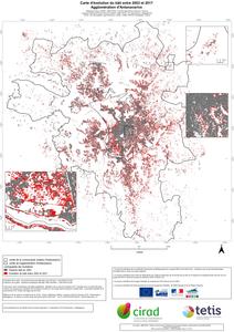
Carte d'évolution du bâti entre 2003 et 2017. Agglomération d'Antananarivo.
Dupuy Stéphane, Defrise Laurence, Burnod Perrine.
2019.
Montpellier : CIRAD-UMR TETIS, 1 carte , échelle : 1:50000
Prévisualisation |
![[img]](http://agritrop.cirad.fr/594286/2/Carte_evolution_Tana_A0_v3.jpeg)
 Prévisualisation |


