
Parcourir par Auteur Cirad
Nombre de documents : 95.
Article de revue
Analyse des dynamiques d'urbanisation et des recompositions agricoles : cas d'Antananarivo, Madagascar.
Andriamanga Andoniaina Valérie, Burnod Perrine, Dupuy Stéphane, Ramamonjisoa Bruno.
2024.
Territoire en Mouvement (61-62), 24 p.
![[img]](/style/images/fileicons/text.png)
Prévisualisation |
Generating high-resolution land use and land cover maps for the greater Mariño watershed in 2019 with machine learning.
Vallet Ameline, Dupuy Stéphane, Verlynde Matthieu, Gaetano Raffaele.
2024.
Scientific Data, 11:915, 14 p.
Prévisualisation |
Use of GEDI signal and environmental parameters to improve canopy height estimation over tropical forest ecosystems in Mayotte Island.
Lahssini Kamel, Baghdadi Nicolas, Le Maire Guerric, Dupuy Stéphane, Fayad Ibrahim.
2024.
Canadian Journal of Remote Sensing, 50 (1):2351004, 22 p.
Prévisualisation |
Harmonized in situ datasets for agricultural land use mapping and monitoring in tropical countries.
Jolivot Audrey, Lebourgeois Valentine, Leroux Louise, Ameline Maël, Andriamanga Valérie, Bellon Béatriz, Castets Mathieu, Crespin-Boucaud Arthur, Defourny Pierre, Diaz Santiana, Dieye Mohamadou, Dupuy Stéphane, Ferraz Rodrigo P.D., Gaetano Raffaele, Gély Marie, Jahel Camille, Kabore Bertin, Lelong Camille, Le Maire Guerric, Lo Seen Danny, Muthoni Martha, Ndao Babacar, Newby Terrence, de Oliveira Santos Cecília Lira Melo, Rasoamalala Eloise, Simoes Margareth, Thiaw Ibrahima, Timmermans Alice, Tran Annelise, Bégué Agnès.
2021.
Earth System Science Data, 13 (12) : 5951-5967.
Prévisualisation |
Multi-sensor land cover classification with sparsely annotated data based on Convolutional Neural Networks and Self-Distillation.
Gbodjo Jean Eudes, Montet Didier, Ienco Dino, Gaetano Raffaele, Dupuy Stéphane.
2021.
IEEE Journal of Selected Topics in Applied Earth Observations and Remote Sensing, 15 p.
Prévisualisation |
Une agronomie clinique et territoriale pour accompagner la transition vers une économie circulaire autour de l'agriculture : mise à l'épreuve et enseignements du projet GABiR à La Réunion.
Vigne Mathieu, Achard Pascale, Alison Clhoé, Castanier C., Choisis Jean-Philippe, Conrozier Rémi, Courdier Remy, Degenne Pascal, Deulvot Agathe, Dupuy Stéphane, Fevrier Amélie, Hatik Christelle, Huat Joël, Kleinpeter Vivien, Kyulavski Vladislav, Lurette Amandine, Payet A.L., Rondeau P., Soulie Jean-Christophe, Thomas P., Thuriès Laurent, Tillard Emmanuel, Van de Kerchove Virginie, Vayssières Jonathan.
2021.
Agronomie, Environnement et Sociétés, 11 (2), 16 p.
Prévisualisation |
Analyzing urban agriculture's contribution to a southern city's resilience through land cover mapping: The case of Antananarivo, capital of Madagascar.
Dupuy Stéphane, Defrise Laurence, Lebourgeois Valentine, Gaetano Raffaele, Burnod Perrine, Tonneau Jean-Philippe.
2020.
Remote Sensing, 12:1962, 19 p.
Prévisualisation |
Land cover maps of Antananarivo (capital of Madagascar) produced by processing multisource satellite imagery and geospatial reference data.
Dupuy Stéphane, Defrise Laurence, Gaetano Raffaele, Andriamanga Valérie, Rasoamalala Eloise.
2020.
Data in Brief, 31:105952, 13 p.
Prévisualisation |
Classification of crops, pastures, and tree plantations along the season with multi-sensor image time series in a subtropical agricultural region.
de Oliveira Santos Cecília Lira Melo, Lamparelli Rubens Augusto Camargo, Dantas Araújo Figueiredo Gleyce Kelly, Dupuy Stéphane, Boury Julie, dos Santos Luciano Ana Cláudia, da Silva Torres Ricardo, Le Maire Guerric.
2019.
Remote Sensing, 11 (3):334, 27 p.
Prévisualisation |
Mapping land cover on Reunion Island in 2017 using satellite imagery and geospatial ground data.
Dupuy Stéphane, Gaetano Raffaele, Le Mézo Lionel.
2019.
Data in Brief, 28:104934, 12 p.
Prévisualisation |
M3Fusion: A deep learning architecture for multiscale multimodal multitemporal satellite data fusion.
Benedetti Paola, Ienco Dino, Gaetano Raffaele, Osé Kenji, Pensa Ruggero, Dupuy Stéphane.
2018.
IEEE Journal of Selected Topics in Applied Earth Observations and Remote Sensing, 11 (2) : 4939-4949.
Prévisualisation |
A combined random forest and OBIA classification scheme for mapping smallholder agriculture at different nomenclature levels using multisource data (simulated sentinel-2 time series, VHRS and DEM).
Lebourgeois Valentine, Dupuy Stéphane, Vintrou Elodie, Ameline Maël, Butler Suzanne, Bégué Agnès.
2017.
Remote Sensing, 9 (3):259, 20 p.
Prévisualisation |
Apport des images THRS pour la catégorisation des agro-systèmes complexes à Mayotte.
Molina Rafaël, Didelot Dominique, Huat Joël, Dupuy Stéphane, Mathey Jérôme, Puissant Anne.
2016.
Géomatique Expert (111) : 30-37.
Towards a set of agrosystem-specific cropland mapping methods to address the global cropland diversity.
Waldner François, de Abelleyra Diego, Verón Santiago R., Zhang Miao, Wu Bingfang, Plotnikov Dmitry, Bartalev Sergey, Lavreniuk Mykola, Skakun Sergii, Kussul Nataliia, Le Maire Guerric, Dupuy Stéphane, Jarvis Ian, Defourny Pierre.
2016.
International Journal of Remote Sensing, 37 (14) : 3196-3231.
Prévisualisation |
Assessing the distribution of disease-bearing rodents in human-modified tropical landscapes.
Morand Serge, Bordes Frédéric, Blasdell Kim R., Pilosof Shai, Cornu Jean-François, Chaisiri Kittipong, Chaval Yannick, Cosson Jean François, Claude Julien, Feyfant Tristan, Herbreteau Vincent, Dupuy Stéphane, Tran Annelise.
2015.
Journal of Applied Ecology, 52 (3) : 784-794.
![[img]](/style/images/fileicons/application_pdf.png)
Building a data set over 12 globally distributed sites to support the development of agriculture monitoring applications with sentinel-2.
Bontemps Sophie, Arias Marcela, Cara Cosmin, Dedieu Gérard, Guzzonato Eric, Hagolle Olivier, Inglada Jordi, Matton Nicolas, Morin David, Popescu Ramona, Rabaute Thierry, Savinaud Mickael, Sepulcre Guadalupe, Valero Silvia, Ahmad Ljaz, Bégué Agnès, Bingfang Wu, de Abelleyra Diego, Diarra Alhousseine, Dupuy Stéphane, French Andrew, ul Hassan Akhtar Ibrar, Kussul Nataliia, Lebourgeois Valentine, Le Page Michel, Newby Terrence, Savin Igor, Verón Santiago R., Koetz Benjamin, Defourny Pierre.
2015.
Remote Sensing, 7 (12) : 16062-16090.
Prévisualisation |
Habitat fragmentation alters the properties of a host-parasite network: rodents and their helminths in South-East Asia.
Bordes Frédéric, Morand Serge, Pilosof Shai, Claude Julien, Krasnov Boris R., Cosson Jean François, Chaval Yannick, Ribas Alexis, Chaisiri Kittipong, Blasdell Kim R., Herbreteau Vincent, Dupuy Stéphane, Tran Annelise.
2015.
Journal of Animal Ecology, 84 (5) : 1253-1263.
Discrimination of tropical agroforestry systems in very high resolution satellite imagery using object-based hierarchical classification: A case-study in Cameroon.
Lelong Camille, Alexandre Cyprien, Dupuy Stéphane.
2014.
South-Eastern European Journal of Earth Observation and Geomatics, 3 (2S) : 255-258. Conference on Geographic Object-Based Image Analysis. 5, Thessaloniki, Grèce, 21 Mai 2014/24 Mai 2014.
Prévisualisation |
Mapping short-rotation plantations at regional scale using MODIS time series: case of eucalypt plantations in Brazil.
Le Maire Guerric, Dupuy Stéphane, Nouvellon Yann, Loos Rodolfo Araujo, Hakamada Rodrigo.
2014.
Remote Sensing of Environment, 152 : 136-149.
Characterization of the horizontal structure of the tropical forestcanopy using object-based LiDAR and multispectral image analysis.
Dupuy Stéphane, Lainé Gérard, Tassin Jacques, Sarrailh Jean-Michel.
2013.
International Journal of Applied Earth Observation and Geoinformation, 25 : 76-86.
The diversity of microparasites of rodents: A comparative analysis that helps in identifying rodent-borne rich habitats in Southeast Asia.
Bordes Frédéric, Herbreteau Vincent, Dupuy Stéphane, Chaval Yannick, Tran Annelise, Morand Serge.
2013.
Infection Ecology and Epidemiology, 1 (20178), 10 p.
Prévisualisation |
Object-based image analysis for operational fine-scale regional mapping of land cover within river corridors from multispectral imagery and thematic data.
Tormos Thierry, Kosuth Pascal, Durrieu Sylvie, Dupuy Stéphane, Villeneuve B., Wasson Jean-Gabriel.
2012.
International Journal of Remote Sensing, 33 (14) : 4603-4633.
An object-based image analysis method for monitoring land conversion by artificial sprawl use of RapidEye and IRS data.
Dupuy Stéphane, Barbe Eric, Balestrat Maud.
2012.
Remote Sensing, 4 (2) : 404-423.
Pour une meilleure gestion des sols de la Martinique, de la Guadeloupe et de la Guyane.
Baillarin Florence, Lainé Gérard, Fotsing J.M., Ariaux B., Dupuy Stéphane.
2008.
SPOT Magazine (44) : 11-14.
Chapitre d'ouvrage
Le maraîchage pour les villes africaines : contributions, défis et innovations au regard de la sécurité alimentaire.
Burnod Perrine, Avadi Angel, Fernandes Paula, Feder Frédéric, Aubry Christine, Nordey Thibault, Defrise Laurence, Djigal Djibril, Jolivot Audrey, Dupuy Stéphane, Assigbetse Komi, David-Benz Hélène, Perrin Coline, Andriamanga Valérie.
2024.
In : Durabilité des systèmes pour la sécurité alimentaire. Combiner les approches locales et globales. Thomas Alban (ed.), Alpha Arlène (ed.), Barczak Aleksandra (ed.), Zakhia-Rozis Nadine (ed.). Versailles : Ed. Quae , 223-235.
(Synthèses : Quae)
ISBN 978-2-7592-3852-1
Prévisualisation |
Market gardening for African cities: contributions, challenges and innovations towards food security.
Burnod Perrine, Avadi Angel, Fernandes Paula, Feder Frédéric, Aubry Christine, Nordey Thibault, Defrise Laurence, Djigal Djibril, Jolivot Audrey, Dupuy Stéphane, Assigbetse Komi, David-Benz Hélène, Perrin Coline, Andriamanga Valérie.
2022.
In : Sustainable food systems for food security. Need for combination of local and global approaches. Thomas Alban (ed.), Alpha Arlène (ed.), Barczak Aleksandra (ed.), Zakhia-Rozis Nadine (ed.). Versailles : Ed. Quae , 201-217.
(Synthèses : Quae)
ISBN 978-2-7592-3575-9
Prévisualisation |
Communication invitée
Cartographie et caractérisation des systèmes agricoles.
Bégué Agnès, Bellon Béatriz, Dessay Nadine, Dupuy Stéphane, Gaetano Raffaele, Inglada Jordi, Le Maire Guerric, Delaitre Eric, Demagistri Laurent, Lebourgeois Valentine, Leroux Louise, Lo Seen Chong Danny, Mitja Danielle, Soti Valérie, Le Toan Thuy.
2018.
In : Apport des observations spatiales pour l'agriculture. Brunet Yves (ed.), Ducharne Agnès (ed.). Académie d'agriculture de France. Paris : Académie d'agriculture de France , Résumé, 1 p.
Séances hebdomadaires de l'Académie d'Agriculture, Paris, France, 7 Février 2018/7 Février 2018.
Prévisualisation |
Prévisualisation |
Communication avec actes
From plot to regional scale, spatial modelling of crop systems using interaction graphs. [P35].
Jahel Camille, Baron Christian, Vall Eric, Bégué Agnès, Dupuy Stéphane, Lo Seen Danny.
2015.
In : Building tomorrow’s research agenda and bridging the science-policy gap. CIRAD, INRA, IRD, Agropolis International, Wageningen UR, CGIAR, UCDAVIS, FAO, Agreenium, GFAR. Montpellier : CIRAD , Résumé, 124.
Climate-Smart Agriculture 2015 : Global Science Conference. 3, Montpellier, France, 16 Mars 2015/18 Mars 2015.
Prévisualisation |
Land pressure and agrarian mutation, spatial modelling of farming systems evolution from plot to regional scale in West Burkina Faso.
Jahel Camille, Baron Christian, Vall Eric, Bégué Agnès, Coulibaly Kalifa, Karambiri Médina, Castets Mathieu, Dupuy Stéphane, Lo Seen Danny.
2015.
In : FSD5 Proceedings: Multi-functional farming systems in a changing world. Gritti Emmanuel S (ed.), Wery Jacques. ESA, Agropolis International. Montpellier : European Society of Agronomy-Agropolis International , 239-240.
International Symposium for Farming Systems Design. 5, Montpellier, France, 7 Septembre 2015/10 Septembre 2015.
Prévisualisation |
Prévisualisation |
Parage project assessing agri-environmental impacts in the French West Indies and French Guiana.
Baillarin Florence, Lainé Gérard, Dupuy Stéphane, Ariaux B., Fotsing J.M., Osé K., Gonzales G..
2009.
In : IGARSS 2009: International Geoscience and Remote Sensing Symposium 2009, July 13-17, 2009, Cape Town, South Africa. s.l. : s.n. , 404-407.
IGARSS 2009, Cape Town, Afrique du Sud, 13 Juillet 2009/17 Juillet 2009.
Communication par affiche
Occupation du sol par télédétection de 2017 à 2022 à La Réunion.
Le Mézo Lionel, Dupuy Stéphane, Gaetano Raffaele.
2023.
. CIRAD. Saint-Gilles : CIRAD-DPP CAPTERRE , 1 p.
Comité scientifique et technique du DPP CapTerre, Saint-Gilles, Réunion, 6 Novembre 2023/6 Novembre 2023.
Prévisualisation |
Brazil - Botucatu (São Paulo).
Le Maire Guerric, Dupuy Stéphane, Boury J., Lebourgeois Valentine, Bégué Agnès.
2016.
. Kyiv : JECAM-GEOGLAM , 1 p.
Joint Experiment for Crop Assessment and Monitoring Science Meeting, Kyiv, Ukraine, 11 Octobre 2016/12 Octobre 2016.
Monitoring the expansion of eucalyptus plantations in Brazil.
Le Maire Guerric, Dupuy Stéphane, Loos Rodolfo Araujo, Hakamada Rodrigo.
2014.
In : International Conference Global Vegetation Monitoring and Modeling, Avignon, France, 3-7 February 2014. s.l. : s.n. , 1 p.
International Conference Global Vegetation Montoring and Modeling, Avignon, France, 3 Février 2014/7 Février 2014.
Prévisualisation |
An OBIA for fine-scale land cover spatial analysis over broad territories: Demonstration through riparian corridor and artificial sprawl studies in France.
Tormos Thierry, Dupuy Stéphane, Van Looy Kris, Barbe Eric, Kosuth Pascal.
2012.
In : 4th International Conference on GEographic Object-Based Image Analysis (GEOBIA 2012), Rio de Janeiro, Brésil, 07- 09 may 2012. Pontifical Catholic University of Rio de Janeiro (PUC-Rio) ; Brazilian National Institute for Space Research (INPE). s.l. : s.n. , 1 p.
International Conference on GEographic Object-Based Image Analysis (GEOBIA 2012). 4, Rio de Janeiro, Brésil, 7 Mai 2012/9 Mai 2012.
Classification et cartographie des espaces boisés de Mayotte : combinaison de données lidar et multispectrales.
Dupuy Stéphane, Lainé Gérard, Tassin Jacques, Sarrailh Jean-Michel.
2011.
In : 22ème Festival International de Géographie (FIG) : L'Afrique plurielle, paradoxes et ambitions, Saint-Dié-des-Vosges, France, 6-9 octobre 2011. s.l. : s.n. , 1 p.
Festival International de Géographie. 22, Saint-Dié-des-Vosges, France, 6 Octobre 2011/9 Octobre 2011.
Prévisualisation |
PARAGE Guadeloupe. Occupation agricole dans les régions Antilles et Guyane : un support spatialisé pour l'évolution de son impact environnemental.
Lainé Gérard, Dupuy Stéphane.
2008.
In : Atelier de restitution finale du Projet PARAGE, Baie-Mahault, Guadeloupe, 17 janvier 2008. s.l. : s.n. , 1 p.
Atelier de Restitution Finale du Projet PARAGE, Baie-Mahault, Guadeloupe, 17 Janvier 2008.
Prévisualisation |
PARAGE Guyane. Occupation agricole dans les régions Antilles et Guyane : un support spatialisé pour l'évolution de son impact environnemental.
Lainé Gérard, Dupuy Stéphane.
2008.
In : Atelier de restitution finale du Projet PARAGE. s.l. : s.n. , 1 p.
Atelier de Restitution Finale du Projet PARAGE, Cayenne, Guyane française, 10 Janvier 2008.
Prévisualisation |
PARAGE Martinique. Occupation agricole dans les régions Antilles et Guyane : un support spatialisé pour l'évolution de son impact environnemental.
Lainé Gérard, Dupuy Stéphane.
2008.
In : Atelier de restitution finale du Projet PARAGE. s.l. : s.n. , 1 p.
Atelier de Restitution Finale du Projet PARAGE, Le Lamentin, Martinique, 14 Janvier 2008.
Prévisualisation |
PARAGE. Occupation agricole dans les régions Antilles et Guyane : un support spatialisé pour l'évolution de son impact environnemental.
Lainé Gérard, Dupuy Stéphane.
2008.
In : Atelier de restitution finale du Projet PARAGE. s.l. : s.n. , 1 p.
Atelier de Restitution Finale du Projet PARAGE, Cayenne, Guyane française, 10 Janvier 2008.
Prévisualisation |
Communication sans actes
The MORINGA processing chain: Automatic object-based land cover classification of tropical agrosystems using multi-sensor satellite imagery.
Gaetano Raffaele, Dupuy Stéphane, Lebourgeois Valentine, Le Maire Guerric, Tran Annelise, Jolivot Audrey, Bégué Agnès.
2019.
. Milan : Italian Space Agency , 3 p.
2019 Living Planet Symposium, Milan, Italie, 13 Mai 2019/17 Mai 2019.
Prévisualisation |
Prévisualisation |
Maintenir l'agriculture urbaine au nom de la sécurité alimentaire : est-ce pertinent ? Cas de Antananarivo - Madagascar.
Burnod Perrine, Defrise Laurence, Aubry Christine, Andriamanana V., Dupuy Stéphane, Perrin Coline, Benz Hélène, Andriandralambo Norontsoa, Bélières Jean-François.
2019.
. Montpellier : INRA-CIRAD , Résumé, 1 p.
Journée du méta programme GloFoodS, Montpellier, France, 13 Juillet 2019/13 Juillet 2019.
Moringa pour cartographier l'occupation du sol à la Reunion et Antananarivo.
Dupuy Stéphane, Defrise Laurence, Lebourgeois Valentine, Le Mézo Lionel, Gaetano Raffaele.
2019.
. Saint-Pierre : s.n. , Résumé, 2 p.
Rencontres Géomatique de La Réunion (RGR 2019), Saint-Pierre, Réunion, 19 Février 2019/19 Février 2019.
Prévisualisation |
Prévisualisation |
M3Fusion : Un modèle d'apprentissage profond pour la fusion de données satellitaires Multi-{Echelles/Modalités/Temporelles}.
Benedetti Paola, Gaetano Raffaele, Osé Kenji, Pensa Ruggero, Dupuy Stéphane, Ienco Dino.
2018.
. SFPT. Marne-la-Vallée : s.n. , 8 p.
Conférence Française de Photogrammétrie et de Télédétection, Marne-la-Vallée, France, 26 Juin 2018/27 Juin 2018.
Prévisualisation |
Cartographie de l'occupation du sol agricole à la Réunion utilisation d'images gratuites et de logiciels libres.
Dupuy Stéphane, Londoño Villegas Mónica María, Lebourgeois Valentine, Le Maire Guerric, Tran Annelise, Gaetano Raffaele.
2017.
. s.l. : s.n. , 2 p.
Rencontres Géomatique de La Réunion (RGR2017), Saint-Pierre, Réunion, 16 Novembre 2017/16 Novembre 2017.
Prévisualisation |
Prévisualisation |
Cartographie et caractérisation des systèmes agricoles.
Bégué Agnès, Bellon De La Cruz Beatriz, Dessay Nadine, Dupuy Stéphane, Gaetano Raffaele, Inglada Jordi, Le Maire Guerric, Delaitre Eric, Demagistri Laurent, Lebourgeois Valentine, Leroux Louise, Lo Seen Danny, Mitja Danielle, Soti Valérie, Le Toan Thuy.
2017.
Prévisualisation |
Prévisualisation |
Mapping smallholder agriculture using simulated Sentinel-2 data; optimization of a Random Forest-based approach and evaluation on Madagascar site.
Lebourgeois Valentine, Dupuy Stéphane, Vintrou Elodie, Ameline Maël, Butler Suzanne, Bégué Agnès.
2017.
Prévisualisation |
Prévisualisation |
Discrimination of tropical agroforestry systems in very high resolution satellite imagery using object-based hierarchical classification: a case-study on cocoa in Cameroon.
Dupuy Stéphane, Lelong Camille, Alexandre Cyprien.
2014.
In : 5th GEOBIA Conference, 21-24 May 2004, Thessaloniki, Grece. s.l. : s.n. , Diaporama, (21 vues)
Conference on Geographic Object-Based Image Analysis. 5, Thessaloniki, Grèce, 21 Mai 2014/24 Mai 2014.
Prévisualisation |
Identifying cropped areas in small growers agricultural regions using data mining for food security.
Vintrou Elodie, Lebourgeois Valentine, Bégué Agnès, Ienco Dino, Teisseire Maguelonne, Dupuy Stéphane, Andriandrahona Fidiniaina Ramahandry.
2014.
In : SENTINEL-2 for Science Workshop, Frascati, Italy, 20-22 May 2014. ESA. s.l. : s.n. , Diaporama, 8 p.
SENTINEL-2 for Science Workshop, Frascati, Italie, 20 Mai 2014/22 Mai 2014.
Prévisualisation |
Potential of Pléiades mono- and tri-stereoscopic images for the agricultural mapping in Mayotte.
Dupuy Stéphane, Lelong Camille, Marty Stéphane.
2014.
In : The Pléiades Days, April 1-3, 2014, Toulouse, France. CNES. s.l. : s.n. , Résumé, 1 p.
Pléiades Days, Toulouse, France, 1 Avril 2014/3 Avril 2014.
Prévisualisation |
Prévisualisation |
Identifying optimal classification rules for geographic object-based image analysis.
Arvor Damien, Saint-Geours Nathalie, Dupuy Stéphane, Andrés Samuel, Durieux Laurent.
2013.
In : Anais XVI Simposio Brasileiro de Sensoriamento Remoto (SBSR), Foz do Iguaçu, Brasil, 13 a 18 de abril de 2013. INPE. s.l. : s.n. , 2290-2297.
Simpósio Brasileiro de Sensoriamento Remoto. 16, Foz do Iguaçu, Brésil, 13 Avril 2013/18 Avril 2013.
Prévisualisation |
Habitat suitability modeling of murine rodents in South-East Asia: use of high resolution data at a local scale.
Herbreteau Vincent, Dupuy Stéphane, Feyfant Tristan, Morand Serge, Tran Annelise.
2012.
In : Regional Workshop on Rodent Survey: from Trapping to Pathogen Screening, Bangkok, Thailand, May 15-18, 2012. s.l. : s.n. , Diaporama, (59 vues)
Regional Workshop on Rodent Survey: from Trapping to Pathogen Screening, Bangkok, Thaïlande, 15 Mai 2012/18 Mai 2012.
Land-cover dynamics in Southeast Asia: Contribution of object-oriented techniques for change detection.
Dupuy Stéphane, Herbreteau Vincent, Feyfant Tristan, Morand Serge, Tran Annelise.
2012.
In : 4th International Conference on GEographic Object-Based Image Analysis (GEOBIA 2012), Rio de Janeiro, Brésil, 07- 09 may 2012. Pontifical Catholic University of Rio de Janeiro (PUC-Rio) ; Brazilian National Institute for Space Research (INPE). s.l. : s.n. , 217-222.
International Conference on GEographic Object-Based Image Analysis (GEOBIA 2012). 4, Rio de Janeiro, Brésil, 7 Mai 2012/9 Mai 2012.
Prévisualisation |
Prévisualisation |
OBIA for combining LiDAR and multispectral data to characterize forested areas and land cover in tropical region.
Dupuy Stéphane, Lainé Gérard, Tormos Thierry.
2012.
In : 4th International Conference on GEographic Object-Based Image Analysis (GEOBIA 2012), Rio de Janeiro, Brésil, 07- 09 may 2012. Pontifical Catholic University of Rio de Janeiro (PUC-Rio) ; Brazilian National Institute for Space Research (INPE). s.l. : s.n. , 279-285.
International Conference on GEographic Object-Based Image Analysis (GEOBIA 2012). 4, Rio de Janeiro, Brésil, 7 Mai 2012/9 Mai 2012.
Habitat suitability modeling of murine rodents in South-East Asia: use of high resolution data at a local scale.
Herbreteau Vincent, Dupuy Stéphane, Feyfant Tristan, Morand Serge.
2011.
In : VIth European Congress of Mammalogy (ECM 2011), Session 9 : Mammals and landscape, Paris, France, July 19-23, 2011. s.l. : s.n. , Diaporama, (42 vues)
European Congress of Mammalogy. 6, Paris, France, 19 Juillet 2011/23 Juillet 2011.
Prévisualisation |
PARAGE Project. Assessing agri-environmental impacts in the French West Indies and French Guiana.
Baillarin Florence, Gonzales G., Lainé Gérard, Dupuy Stéphane, Ariaux B., Desprès D., Fotsing J.M., Osé K..
2008.
In : 28th EARSel Symposium Remote Sensing for a Changing Europe, Istambul, 2-7 juin 2008. s.l. : s.n. , 8 p.
EARSel Symposium Remote Sensing for a Changing Europe. 28, Istanbul, Turquie, 2 Juin 2008/7 Juin 2008.
Prévisualisation |
Prévisualisation |
Rapport d'expertise
BIOTAMAYA. Rapport méthodologique pour la production de carte d'occupation du sol- Mayotte en 2023.
Dupuy Stéphane, Lelong Camille, Gaetano Raffaele, Villers Alexandre.
2024.
Montpellier : CIRAD-ES-UMR TETIS, 78 p.
Prévisualisation |
Rapport de fin de projet : Formation en cartographie de l'occupation du sol par télédétection du Centre National de l'Information Géo-Spatiale (CNIGS) de la République d'Haïti (Projet Territoires Productifs Résilients).
Lelong Camille, Dupuy Stéphane, Gaetano Raffaele.
2021.
Montpellier : CIRAD-ES-UMR TETIS, 24 p.
Prévisualisation |
Rapport méthodologique : Cartographie de l'occupation du sol sur le site des NIPPES à Haïti.
Dupuy Stéphane, Lelong Camille, Gaetano Raffaele.
2021.
Montpellier : CIRAD-ES-UMR TETIS, 45 p.
Prévisualisation |
Rapport méthodologique : inter-comparaison des produits de cartographie de l'occupation du sol avec les chaines Iota2 et Moringa : cas d'étude de la région des Nippes en Haïti.
Gaetano Raffaele, Lelong Camille, Dupuy Stéphane.
2021.
Montpellier : CIRAD, 31 p.
Prévisualisation |
Formation et renforcement des capacités en cartographie de l'occupation du sol par télédétection du Centre National de l'Information Géo-Spatiale (CNIGS) de la République d'Haïti.
Lelong Camille, Gaetano Raffaele, Dupuy Stéphane.
2020.
Montpellier : CIRAD-ES-UMR TETIS, 16 p.
Prévisualisation |
Production des cartes de l'occupation du sol agricole à la Réunion à partir d'images satellites 2016 – 2019 - Rapport méthodologique.
Dupuy Stéphane, Gaetano Raffaele.
2019.
Saint-Pierre : CIRAD-ES-UMR TETIS, 61 p.
Prévisualisation |
Photo-interprétation d'images acquises par drone, classification d'images satellite et modélisation des processus de propagation des lianes provoquant l'effondrement de peuplements forestiers.
Mercy Laurent, Lartigue Jeannette, Thongo Agnès, Lamalfa Diaz Miguel, Dupuy Stéphane, Tran Annelise, Degenne Pascal, Iratchet Bruno, Capel Anne Cécile.
2018.
s.l. : ONF-CIRAD, 59 p.
Document technique et de recherche
Évolution de l'occupation et des modes d'usage des sols et stratégies d'adaptation des exploitations agricoles familiales dans la commune rurale de Mandritsara (région Vakinankaratra, Madagascar).
Grislain Quentin, Dupuy Stéphane, Razanakolona Lydia, Lebourgeois Valentine, Vigne Mathieu, Razafinarivo Tsirinirina, Bélières Jean-François.
2024.
Antananarivo : CIRAD-FOFIFA, 87 p.
Fiche descriptive de la production des cartes d'occupation du sol 2022-2023 à Madagascar dans le cadre du projet DINAAMICC.
Dupuy Stéphane.
2023.
Montpellier : CIRAD, 16 p.
Prévisualisation |
Rapport sur la formation à la collecte et à la construction d'une base de données de vérité-terrain à l'aide du logiciel QGIS, de tablettes Android et de l'application QField. Formation organisée dans le cadre du projet DINAAMICC du 7 au 10 mars 2023 à Antsirabe - Madagascar.
Dupuy Stéphane.
2023.
Montpellier : CIRAD, 41 p.
Prévisualisation |
Rapport méthodologique pour la production des cartes d'occupation du sol 2022 de l'agglomération d'Antananarivo - Madagascar.
Dupuy Stéphane, Andriamanga Andoniaina Valérie, Gaetano Raffaele, Burnod Perrine.
2022.
Montpellier : CIRAD, 17 p.
Prévisualisation |
Guide technique. Constitution d'une base de données de référence dédiée à l'apprentissage et la validation des classifications d'images satellites : la vérité-terrain.
Lelong Camille, Dupuy Stéphane.
2021.
Montpellier : CIRAD-ES-UMR TETIS, 16 p.
Prévisualisation |
Rapport sur la formation GPS, SIG et Télédétection, Conseil Départemental de Mayotte.
Dupuy Stéphane, Tran Annelise.
2020.
Montpellier : CIRAD, 19 p.
Prévisualisation |
Cartographie de l'occupation du sol agricole sur l'île de la Réunion à partir d'images satellites.
Dupuy Stéphane.
2019.
Saint-Denis : CIRAD-Projet GABIR, 4 p.
Prévisualisation |
Fiche complémentaire de la couche " Carte d'occupation du sol 2017 à la Réunion ".
Dupuy Stéphane.
2018.
Saint-Pierre : CIRAD, 9 p.
Prévisualisation |
Synthèse d'évaluation de la formation: "Analyse orientée d'images de télédétection (eCognition)" : 22 au 26 octobre 2012 Saint Pierre - Réunion (France).
Dupuy Stéphane, Paulet Florence, Tormos Thierry.
2012.
Montpellier : CIRAD, 34 p.
Analyse du potentiel agronomique des terres affectées par l'aménagement du territoire en Languedoc-Roussillon : phase 2 2009 / 2010. Application des méthodologies de quantification des terres artificialisées et de cararctérisation des dynamiques de consommation des terres sur les départements littoraux du Languedoc Roussillon.
Balestrat Maud, Barbe Eric, Dupuy Stéphane.
2011.
Montpellier : UMR TETIS, 142 p.
Consommation de terres agricoles.
Barbe Eric, Balestrat Maud, Dupuy Stéphane, Martinand Pierre.
2010.
Montpellier : UMR TETIS, 1 affiche
Etude de la typologie forestière de Mayotte : Rapport final, juillet 2010. Contrat Cadre EuropeAid/119860/C/SV/Multi.
Lainé Gérard, Dupuy Stéphane, Tassin Jacques, Sarrailh Jean-Michel.
2010.
Montpellier : CIRAD, 120 p.
Les six réserves forestières de Mayotte : Typologie des espaces boisés de Mayotte [Gestion des forêts mahoraises : utilisation de données "LIDAR"].
Lainé Gérard, Dupuy Stéphane, Tassin Jacques, Sarrailh Jean-Michel.
2010.
Montpellier : CIRAD, 1 affiche
Analyse du potentiel des terres agricoles affectées par l'aménagement du territoire : étude méthodologique sur une zone pilote (Département de l'hérault- 34).
Balestrat Maud, Barbe Eric, Dupuy Stéphane, Lagacherie Philippe, Ménard Thomas.
2008.
Antony : CEMAGREF, 137 p.
Prévisualisation |
Compte rendu final du projet AgriDrone : utilisation de capteurs embarqués sur drone pour caractériser l'état hydrique et nutritif des cultures; application à la canne à sucre sur le site pilote de l'île de La Réunion.
Bégué Agnès,
Lebourgeois
Valentine (collab.), Houles
Marion (collab.), Degenne
Pascal (collab.), Labbé
Sylvain (collab.), Dupuy
Stéphane (collab.), Roux
Bruno (collab.).
2008.
Montpellier : CIRAD, 35 p.
Prévisualisation |
Prévisualisation |
Rapport de mission
Rapport sur la formation à la collecte et à la construction d'une base de données de vérité-terrain à l'aide du logiciel QGIS, de tablettes Android et de l'application QField. 03-07 octobre 2022.
Dupuy Stéphane.
2023.
Montpellier : CIRAD, 45 p.
Prévisualisation |
Support de cours
Formation à la réalisation d'une carte d'occupation du sol à partir d'images Sentinel2 - Travaux pratiques avec OTB et Qgis.
Jolivot Audrey, Dupuy Stéphane.
2023.
Montpellier : CIRAD, 31 p.
Prévisualisation |
Guide technique pour la construction d'une base de données de vérité-terrain pour l'apprentissage et la validation des algorithmes de classification d'images satellites : Principes de base et manuel pratique mobilisant le logiciel QGIS et l'application QField.
Dupuy Stéphane, Jolivot Audrey, Lebourgeois Valentine, Lelong Camille.
2022.
Montpellier : CIRAD, 45 p.
Prévisualisation |
Prévisualisation |
Travaux Pratiques : Initiation à la télédétection avec Orfeo ToolBox et QGIS.
Dupuy Stéphane.
2021.
Montpellier : CIRAD-ES-UMR TETIS, 41 p.
Prévisualisation |
Support de travaux pratiques de la formation à l'utilisation des images Spot6/7 et Pléiades avec OTB et QGIS, Mayotte.
Dupuy Stéphane, Tran Annelise.
2020.
Montpellier : CIRAD-ES-UMR TETIS, 16 p.
Prévisualisation |
Support pour travaux pratiques de la formation prise en main du logiciel QGIS, Mayotte.
Tran Annelise, Dupuy Stéphane.
2020.
Montpellier : CIRAD-ES-UMR TETIS, 28 p.
Prévisualisation |
Support pour travaux pratiques de la formation à l'utilisation d'un GPS Garmin Map64, Mayotte.
Tran Annelise, Dupuy Stéphane.
2020.
Montpellier : CIRAD-ES-UMR TETIS, 30 p.
Prévisualisation |
Analyse orientée objet d'images de télédétection. Prise en main d'eCognition Developer.
Dupuy Stéphane, Tormos Thierry.
2011.
Paris : AgroParisTech, 86 p.
Prévisualisation |
Segmentation et classification d'images en télédétection : l'approche orientée objet sous eCognition.
Tormos Thierry, Dupuy Stéphane.
2011.
s.l. : s.n., 1 diaporama (21 vues)
Prévisualisation |
Carte
Occupation du sol - Mayotte - Carte de 2023.
Dupuy Stéphane, Lelong Camille, Gaetano Raffaele, Villers Alexandre.
2024.
Montpellier : CIRAD-OFB, 1 carte , échelle : 1:43000
Prévisualisation |
Carte d'occupation du sol de l'agglomération d'Antananarivo : les espaces agricoles urbains (2022).
Dupuy Stéphane, Andriamanga Andoniaina Valérie, Gaetano Raffaele, Burnod Perrine.
2022.
Montpellier : CIRAD-UMR TETIS, 1 carte , échelle : 1:45953
![[img]](/604228/2/Carte_Tana_2022_A0_v4.jpg)
 Prévisualisation |
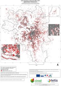
Carte d'évolution du bâti entre 2003 et 2017. Agglomération d'Antananarivo.
Dupuy Stéphane, Defrise Laurence, Burnod Perrine.
2019.
Montpellier : CIRAD-UMR TETIS, 1 carte , échelle : 1:50000
Prévisualisation |
![[img]](/594286/2/Carte_evolution_Tana_A0_v3.jpeg)
 Prévisualisation |
Ile de la Réunion. Carte d'occupation du sol en 2018.
Dupuy Stéphane, Gaetano Raffaele.
2019.
Montpellier : CIRAD-UMR TETIS, 1 carte , échelle : 1:80000
![[img]](/594033/2/Classif_pleiades2018_a0_150dpi.jpeg)
Carte d'occupation du sol de l'agglomération d'Antananarivo : les espaces agricoles (2017).
Dupuy Stéphane, Defrise Laurence, Burnod Perrine, Gaetano Raffaele.
2018.
Montpellier : CIRAD, 1 carte
Prévisualisation |
Ile de la Réunion carte d'occupation du sol en 2017.
Dupuy Stéphane, Le Mézo Lionel, Gaetano Raffaele.
2018.
Saint Denis : CIRAD-ES-UMR TETIS, 1 carte
Prévisualisation |
Cartographie des zones artificialisées en Languedoc Roussillon. Situation en 2009.
Dupuy Stéphane, Barbe Eric, Balestrat Maud.
2011.
Montpellier : CIRAD-CEMAGREF, 1 carte , échelle : 1:320000
Evolution des taches artificialisées du Languedoc-Roussillon entre 1997 et 2009.
Dupuy Stéphane, Barbe Eric, Balestrat Maud.
2011.
Montpellier : CIRAD-CEMAGREF, 1 carte , échelle : 1:320000
Typologie des espaces boisés de Mayotte. Situation en 2008.
Lainé Gérard, Dupuy Stéphane, Tassin Jacques, Sarrailh Jean-Michel.
2010.
Montpellier : CIRAD, 1 carte , échelle : 1:50000


